Nigeria Hydrological Services Agency, NIHSA, has urged states, LGAs and the general public to take preventive measures as Jigawa and Lagos record worst flooding incident cases.
The Director General of the NIHSA, Clement Nze, made the call in Abuja on Wednesday at the ‘Overview of 2022 Annual Flood Outlook (AFO): Update on Flood Situations in the Country’, whereby he revealed that Jigawa was the worst hit state with many lives and property lost, followed by Lagos State.
Nze stated that the 2022 AFO presented on the 12th May, 2022 by the Honourable Minister of Water Resources, Engr Suleiman Adamu categorised the expected flood in 2022 into three different scenarios for the duration of the rainy season in Nigeria. The first category was the Seasonal Flood Outlook for the Months of April, May and June (AMJ), second category was for the Months of July, August and Sept (JAS), and the third outlook being for October and November (ON).
He therefore called on states, LGAs and the general public to take necessary measures to avert flood disasters.
He said, “The general outlook shows that: 233 Local Government Areas (LGAS) in 32 States of the Federation and the FCT fall within the Highly Probable Flood Risk Areas; 212 LGAs in 35 States of the Federation including the FCT fall within the Moderately Probable Flood Risk Areas, while the remaining 329 LGAs fall within the Probable Flood Risk Areas.
“The Highly Probable Flood Risk States as predicted are Adamawa, Abia, Akwa Ibom, Anambra, Bauchi, Bayelsa, Benue, Cross-River, Delta, Ebonyi, Ekiti, Edo, Gombe, Imo, Jigawa, Kaduna, Kano, Kebbi, Kogi, Kwara, Lagos, Nasarawa, Niger, Ogun, Ondo, Osun, Oyo, Rivers, Sokoto, Taraba, Yobe, Zamfara and the FCT.
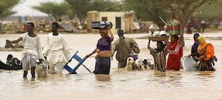
“The worst hit state is Jigawa (with 16 LGAs affected and more than 50 lives lost; while property, livelihoods and infrastructure were damaged. Lagos is next with 14 LGAs and many casualties recorded. Other flood-hit states include Nasarawa (Keffi), Anambra (Onitsha), Ima (Owerri), Abla (Aba), Kwara (Ilorin, Offa), Kaduna (Kaduna), Rivers (Bori), Enugu (Enugu), Ogun (Ijebu Ode), Delta (Asaba), Taraba (Jalingo), Yobe (Gashua), Elditi (Ado Ekiti), Borno, Ondo (Akure town), Oyo (Iseyin, Eruwa), Katsina, Maiduguri.”
The DG noted that as early as April this year, some states had begun to experience flooding, adding that as at today, flood disasters have occurred in many states with loss of lives and properties.
He however pointed out that virtually all the flood disasters experienced are caused by overflow of painted rivers among others.
“It must be pointed out that virtually all the flood incidents above were caused by overflow of silted rivers and poor drainage systems as a result of localized rainfall that generated flash/urban flooding in the urban areas and metropolis. As at today, both Kainji and Jebba Dams on River Niger are still impounding water into their reservoirs. Shiroro Dam on River Kaduna is equally impounding water. No release of water from any of the Dams within and outside Nigeria,” said the Director General, Clement Nze.
To further avert the menace of the past years, the agency recommended the following: “Clearing of blocked drainage systems and canals, removal of refuse, weeds, water hyacinths, and floats on water channels, relocate to higher grounds people living along the water-ways and those carrying out socio-economic activities on the flood plains;
“Improved system for flood monitoring, flood forecasting and flood early warning, effective and efficient operational procedure for dams and reservoirs and maintenance of other hydraulic and water infrastructure across the country, construction of dykes, flood-walls, buffer dams, detention basins and water retaining structures.”
Other recommendations were, “Carrying out River Training activities and maintenance of drainages by the removal of silt and sediment deposits in rivers to improve their conveyance capacities and from dams, lakes and reservoirs to increase their storage capacities for the containment of the incoming floodwaters.
“Construction of weirs, small reservoirs on tributaries of major rivers, streams and rivers for conservation of floodwater to be used during the dry season thereby preventing desert encroachment, increasing irrigation for food crop production, improvement of grassland areas, nomadic settlement, peace and sustainable development. Intensification of soil conservation measuring techniques on the drainage areas to reduce soil erosion and increase ecosystem protection among others.
“Enforcement of Town Planning Codes in the country to allow for the construction of houses, and drainage structures as outlined by Town Planners. Constantly freeing the waterways from obstructions and provision of adequate refuse dumping facilities.”
He also said the agency is also monitoring the developments on the River Benue Sub Basin and is keeping close contact with the Cameroonian authorities with regard to flood scenarios in the upper catchment of the Sub-Basin.